Auto
 2 weeks ago
2

Published Oct 19, 2026, 1:00 PM EDT
Jonathon Jachura is a mechanical engineer with over 12 years of HVAC industry experience who specializes in translating complex home systems into practical advice for everyday homeowners. His background spans technical sales and product management for major manufacturers, combined with hands-on experience as a two-time homeowner who has tackled everything from system installations to troubleshooting repairs. Jon focuses on helping readers make confident decisions about their homes through clear, actionable guidance that saves both time and money.
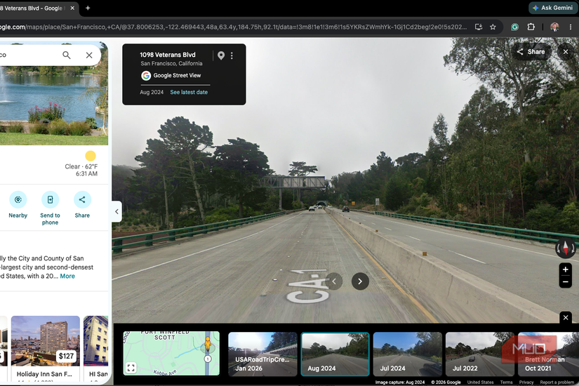
Street View usually shows a road the way it looked on the last drive-by, which could be months or years old. Most people never notice that Google kept the earlier captures, too. Tap See more dates inside Street View, and Google Maps opens a timeline of every published pass down that road, reaching back to 2007 in the places Google photographed first.
I recently wrote about how Google Maps remembers more about your life than you probably realize, and this archive is the friendlier side of that memory. It holds the gas station that closed, the tree a storm took down, and the house you grew up in before someone else painted it. It’s free, and it’s already on your phone and computer.
Street View kept every pass of the camera car
The archive starts in 2007 for the first cities
 Credit: Jonathon Jachura / MUO
The first Street View cars hit the road in May 2007, covering New York, San Francisco, Las Vegas, Denver, and Miami before anywhere else. Those streets hold the deepest archives. Smaller towns and rural roads were added later, sometimes much later, so your hometown’s timeline may begin several years after launch.
For a long time, the history sat out of reach for most people. Desktop users got a time slider in 2014. Phones didn’t get this feature until 2022, when Google celebrated Street View’s 15th birthday by adding the same control to the iPhone and Android apps. Google Earth picked it up in 2025.
Coverage isn’t annual. A busy downtown block might show a fresh capture every year or two, while a county road can go six or seven years between visits.
Opening the archive takes a few taps
Look for See more dates on your phone or computer
 Credit: Jonathon Jachura / MUO
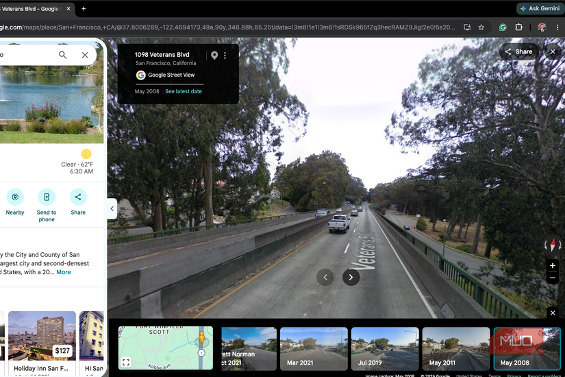
On an iPhone or Android phone, open Google Maps, drop a pin on an address, and tap the Street View thumbnail that appears with it. Once you’re inside Street View, tap anywhere on the image to bring up the location card, then tap See more dates. A row of thumbnails appears along the bottom, and every one shows the month and year Google drove past. Swipe to the end of the row and tap the oldest.
On desktop, drop Pegman, the little yellow figure in the bottom-right corner, onto any blue road. Click See more dates in the top-left box and scroll right until the thumbnails run out. Click See latest date to return to the present.
If the button vanishes, move a few steps down the road. Historical coverage is tied to specific points, so one stretch of pavement can have five captures while the next has one. A bigger screen makes the whole thing more enjoyable, whether that’s a laptop or an old iPad you’ve kept around.
I went back to LaCrosse first
My childhood home hasn’t changed much
The first address I typed in was my childhood home in LaCrosse, Indiana. The oldest capture available was from October 2009, a year after I graduated high school. I saw the black Chevy Cavalier that rotated between every member of our family for several years parked in the driveway.
The newest capture is from May 2024 and shows the 100+-year-old house's age and how the current owners are in the process of moving the front door to where a window used to be.
It’s a bit like finding a photo album you didn’t know your family kept. The tiny details hit hardest, like a replaced mailbox or a repainted garage door, since nobody ever bothered to photograph those changes.
Now to my current home
My existing home tells a different story
Then I checked my current house in a different town. It’s new construction with street view data from only the main road. The earliest capture shows an empty field in 2007, fully grown corn in 2013, developed land in 2019, and my completed house in the background in 2023.
It was interesting to see how the area changed and developed into a neighborhood.
It will also give the trees I’ve planted a real timeline. I used a free app to find the best spot for shade trees, and future captures will show whether I picked well.
Old captures solve practical problems, too
Check the timeline before you buy, build, or plant

House hunters get the most out of this. A flipped home’s listing won’t mention the mature tree that came down or when the back addition went up, but older captures usually reveal both. Realtor photos are staged. Street View caught the place on a random weekday, trash cans and all.
It also helps with questions about your own neighborhood. You can roughly date when a neighbor’s fence went up or when the road out front was widened. You’ll only know the change happened somewhere between two captures, but that window is often narrow enough to be useful.
Gardeners can use it, too. Track a neighbor’s maple or spruce through several captures to get a realistic growth rate for your climate before planting one near your foundation.
A blur request wipes the history, too
Think twice before you hide your house
 Credit: Jonathon Jachura / MUO
Google lets anyone request that their home be blurred in Street View, and plenty of people do it for privacy. The catch sits in Google’s own policy. A blur is permanent, and it covers every historical capture of the house along with future ones. There’s no process to undo it later, even for a new owner.
That cuts both ways. If the house you grew up in has changed hands, the current owners may have already blurred it, turning your childhood home into a smudge across the entire timeline. If you’re considering a blur for your own place, weigh the privacy gain against erasing nearly two decades of your street’s visual record.
Screenshot your old street before someone blurs it
All it takes is one request from a homeowner, and a whole timeline turns to mush. Grab the captures that matter now. On iPhone, a regular screenshot does the job. Mac users can press Cmd + Shift + 4 and drag a box around just the Street View image. Put the capture date in each file name, or you’ll lose track of which year is which.
Then send a few to the people who lived there with you. Your mom or brother will notice things you didn’t, and that back-and-forth beats the screenshots. Begin with the block where you learned to ride a bike.